
Underwater Tunnel Project Under Brahmaputra to Enhance Assam Connectivity
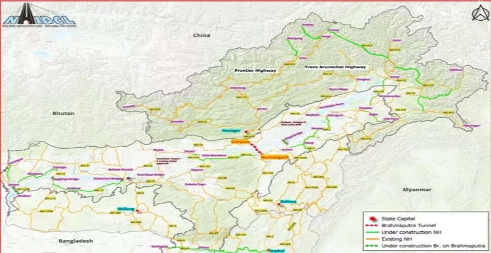

Overview of the Underwater Tunnel Project
Guwahati, Sept 14: A significant underwater rail and road tunnel beneath the Brahmaputra River is set to be developed, featuring four artificial islands that will play a vital role in linking Gohpur and Numaligarh in Assam.
Details of the Artificial Islands
Project documents reveal that two of these islands will be designated for road traffic, while the other two will support railway operations.
The road island on the Gohpur side will extend at least 1.4 km, whereas the corresponding island on the Numaligarh side will measure around 1.6 km. Both islands will be approximately 320 meters wide and will include lay-bys constructed with RCC box structures.
In contrast, the railway islands will be narrower, each measuring 50 meters in width and about 2 km in length.
Engineering Specifications and Safety Measures
The engineering designs are crafted to endure the intense flooding of the Brahmaputra. The finished reclamation level (FRL) of the islands must be at least 2.5 meters above the river's highest flood level (HFL), with additional protective measures tailored to specific site conditions.
The National Highways & Infrastructure Development Corporation Limited (NHIDCL) has recently issued a tender for the construction of a four-lane twin-tube underwater tunnel, along with the necessary approach roads and railway infrastructure.
Project Cost and Timeline
The estimated civil cost for the project is Rs 11,982.36 crore, with a projected construction timeline of five years. The total greenfield alignment will span approximately 33.77 km, which includes a substantial 15.79-km twin-tube underwater tunnel.
Each tunnel tube will feature an internal diameter of 11.5 meters, with cross passages every 500 meters, and the two tubes will be separated by a distance of 25 meters.
Safety and Structural Integrity
A critical safety requirement mandates that the tunnel must have at least 25 meters of riverbed cover above its crown at the maximum scour depth. This ensures that even during extreme flooding, a minimum cushion of earth remains between the eroded riverbed and the tunnel's top.
This precaution is essential as fast-moving floodwaters can erode the riverbed, potentially exposing underground structures. The specified cushion serves as an additional safeguard for the tunnel's structural integrity and waterproofing.
Geological Considerations and Traffic Load
According to project documents, the anticipated geological conditions include very dense, compacted sand and fully saturated soil. However, the contractor will be responsible for conducting detailed geological investigations and finalizing the design. NHIDCL will provide a geotechnical baseline report as part of the project framework.
The tunnel is designed to accommodate a traffic load of approximately 30,756 passenger car units (PCU), with a design speed of 100 km/h and a projected structural lifespan of 100 years.
Impact on Connectivity
This project aims to significantly enhance connectivity between northern and southern Assam by integrating with NH-15 and NH-715. Additionally, it will link two railway networks: the Rangia-Murkongselek section under the Rangia Division of Northeast Frontier Railway on the Gohpur side and the Furkating-Mariani loop line under the Tinsukia Division on the Numaligarh side.
The Cabinet Committee on Economic Affairs, led by Prime Minister Narendra Modi, approved this ambitious project in February 2026.