
UN Embraces Equal Earth Projection: A New Era for Global Mapping

UN General Assembly's Historic Resolution
United Nations: In a significant move to better represent the Global South, the UN General Assembly has endorsed a new world map that accurately depicts the sizes of continents and countries.
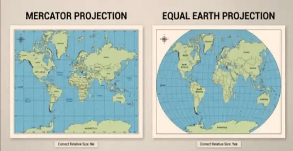
On Friday, the Assembly, with support from India, passed a resolution advocating for the adoption of the Equal Earth Projection, which replaces traditional maps like the Mercator Projection that tend to exaggerate the dimensions of northern countries.
The resolution received overwhelming support with 164 votes in favor, while the United States stood alone in opposition, opting to abstain from the vote.
The Mercator Projection, created by 16th-century cartographer Gerardus Mercator, remains the most widely used mapping system globally.
Originally designed for maritime navigation during the colonial era, this projection reflects a distorted perspective of the world.
Togo's Foreign Minister Robert Dussey, who spearheaded the initiative, stated, “Correcting the map signifies that every region deserves accurate and dignified representation.”
The representation of India remains largely unchanged in the Equal Earth Projection, with only minor adjustments to the peninsular region.
In contrast, the United States appears smaller on this new map, providing a more accurate representation of its geographical size compared to other nations.
This visual reduction has previously sparked controversy in the US, particularly during Donald Trump's presidency, when he expressed desires to expand US territory.
Yaryna Ferencevych, a deputy representative from the US, criticized the resolution, labeling it as part of a broader ideological agenda that undermines the UN's credibility.
Dussey emphasized that the initiative is not aimed against any specific nation or civilization, asserting, “A fair map doesn’t alter geography; it transforms our worldview.”
He added that a more equitable perspective fosters understanding, respect, and peace among nations.
Interestingly, while Russia, which appears significantly smaller on the Equal Earth map, supported the resolution, calling it an anti-colonial measure.
It is important to note that the Assembly's resolution is advisory and does not compel any nation or organization to abandon the Mercator maps.
The European Union, which backed the resolution, clarified that it is intended solely for educational and geographical literacy purposes.
Earlier, the French Foreign Minister announced that France would discontinue the use of Mercator maps, opting for representations that better reflect actual land areas.
The distortions of the Mercator projection are particularly evident in the portrayal of Greenland, which is inaccurately depicted as being comparable in size to Africa, despite Africa being 14 times larger, and Europe appearing larger than South America, which is actually about 75% bigger.